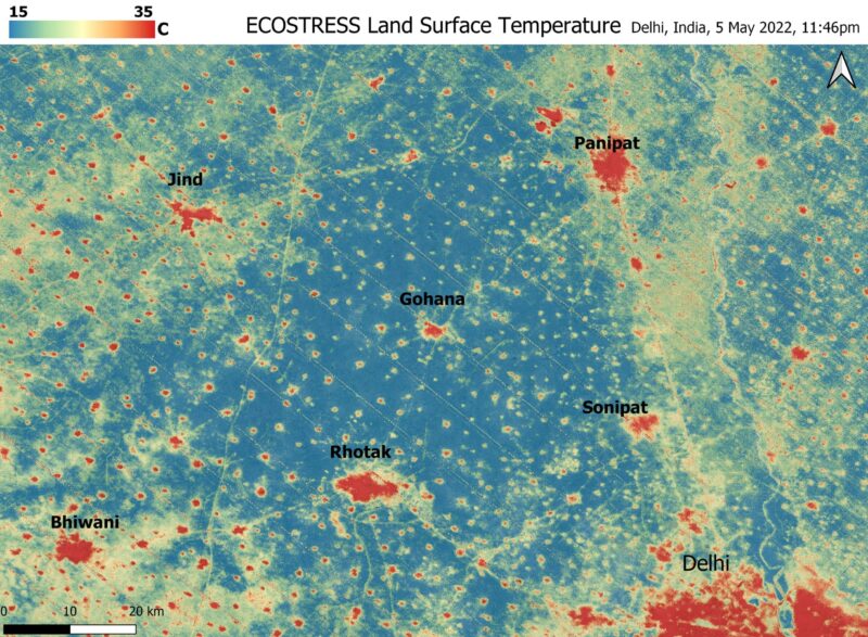

L’instrument ECOSTRESS de la NASA a réalisé cette image des températures au sol près de Delhi (en bas à droite), vers minuit le 5 mai. Les “îlots de chaleur” urbains de Delhi et des petits villages ont atteint un pic de 102 degrés Fahrenheit (39 degrés Celsius), tandis que les champs voisins étaient environ 40 degrés Fahrenheit plus frais. Crédit : NASA/JPL-Caltech
L’instrument à bord de la station spatiale documente les températures torrides dans les zones urbaines autour de Delhi pendant la vague de chaleur historique sur le sous-continent indien.
Une vague de chaleur incessante s’est abattue sur l’Inde et le Pakistan depuis la mi-mars, causant des dizaines de morts, des incendies, une augmentation de la pollution atmosphérique et une réduction du rendement des cultures. Les prévisions météorologiques ne laissent entrevoir aucun répit dans l’immédiat. ;” data-gt-translate-attributes=”[{” attribute=””>NASA’s Ecosystem Spaceborne Thermal Radiometer Experiment on Space Station instrument (ECOSTRESS) has been measuring these temperatures from space, at the highest spatial resolution of any satellite instrument.
This ECOSTRESS Land Surface Temperature image, taken shortly before local midnight on May 5, shows urban areas and agricultural lands northwest of Delhi (the large red area in the lower right) that are home to about 28 million people. The image covers about 4,800 square miles (12,350 square kilometers).
Cities are usually markedly warmer than the surrounding countryside due to human activities and the materials used in the built environment. The image clearly delineates these urban “heat islands.” Nighttime temperatures in Delhi and several smaller villages were above 95 degrees Fahrenheit (35 degrees Celsius), peaking at about 102 degrees F (39 degrees C), while the rural fields nearby had cooled to around 60 degrees F (15 degrees C). This data suggests that city dwellers are experiencing considerably higher temperatures than the average temperatures recorded for their regions.
ECOSTRESS measures the temperature of the ground itself, which is very similar to air temperature at night (though the ground may be warmer than the air in daylight hours). The instrument was launched to the space station in 2018. Its primary mission is to identify plants’ thresholds for water use and water stress, giving insight into their ability to adapt to a warming climate. However, ECOSTRESS also records other heat-related phenomena, like this heat wave. With a pixel size of about 225 feet (70 meters) by 125 feet (38 meters), its high-resolution images serve as a powerful tool for understanding aspects of the weather event that might be overlooked by traditional observation networks.
NASA’s Jet Propulsion Laboratory (JPL) in Southern California built and manages the ECOSTRESS mission for the Earth Science Division in the Science Mission Directorate at NASA Headquarters in Washington. ECOSTRESS is an Earth Venture Instrument mission; the program is managed by NASA’s Earth System Science Pathfinder program at NASA’s Langley Research Center in Hampton, Virginia.