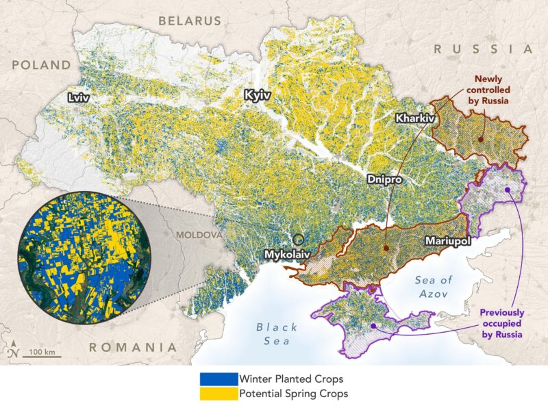

Cette carte montre la répartition des cultures d’été et d’hiver en Ukraine au 13 juin 2022. Elle montre également où les agriculteurs opèrent librement et où leurs terres sont sous contrôle russe. Elle est basée sur les données des satellites Planet Labs et de la mission Sentinel-2 de l’Agence spatiale européenne qui ont été traitées et analysées par la NASA Harvest.
;” data-gt-translate-attributes=”[{” attribute=””>NASA Harvest scientists use satellite observations and economic data to track how the Russia-Ukraine conflict is disrupting the global food system.
When farmers in Ukraine planted wheat, canola, barley, and rye in the autumn of 2021, their worries were relatively routine: would dry weather or increasing fertilizer prices cut into their yields and profits? By the time those winter crops emerged from dormancy in the spring of 2022, life in Ukraine had turned completely upside down.
“The world’s breadbasket is at war.” — Inbal Becker-Reshef
Russia had invaded Ukraine. With the war came tanks rolling through fields, farmland covered with mines, and artillery shells raining down on crops. Fuel and fertilizer prices skyrocketed. Labor grew scarce. Some farmers left to join the fighting; others died or fled after their villages were bombarded. Even farmers far from the front lines watched tens of millions of tons of grain and other agricultural goods sit dormant in silos and ports due to a Russian naval blockade. As the battle raged on, even grain and vegetable oil storage facilities became targets.
“The world’s breadbasket is at war,” said Inbal Becker-Reshef, director of NASA’s Harvest program. Before the war, Ukraine provided 46 percent of global sunflower oil exports, 9 percent of the wheat exports, 17 percent of the barley, and 12 percent of the maize on global markets, according to data from the U.S. Foreign Agricultural Service. (Ukraine and Russia together accounted for 73 percent of sunflower oil exports, 33 percent of wheat, and 27 percent of barley.) The past few months have significantly disrupted that flow of food.
“We’re in the beginning stages of a rolling food crisis that will likely affect every country and person on Earth in some way,” said Becker-Reshef. For some populations, this could mean higher prices or missing items at the grocery store. For others, history suggests it could mean more acute food shortages.

Landsat 8 image shows fields of canola blooming in Mykolaiv oblast near Shyrokolanivka on May 20, 2022.
For more than a decade, Becker-Reshef and other NASA-funded scientists have been developing innovative satellite-based techniques to monitor commodity crops such as wheat and maize in Ukraine. The interdisciplinary group collects and analyzes environmental, economic, and social science data in order to improve agriculture-related decision-making around the world. With the arrival of war, such tools could play a key role in anticipating and averting food shortages and famines.
The map at the top of the page—based on data from Planet Labs satellites and the European Space Agency’s Sentinel-2 mission that was processed and analyzed by NASA Harvest—shows the distribution of summer and winter crops in Ukraine as of June 13, 2022. The map also shows where farmers were operating freely and where their lands were under Russian control. Roughly 22 percent of Ukraine’s farmland—including 28 percent of winter crops and 18 percent of summer crops—is under Russian control, according to NASA Harvest’s analysis. Summer crops, mainly maize and sunflower, are grown more widely in northern and western Ukraine than winter crops. (Data on land occupation comes from the Institute for the Study of War and the American Enterprise Institute’s Critical Threats Project.)
The NASA Harvest team, with international partners from the GEO Global Agricultural Monitoring (GEOGLAM) initiative, measure multiple environmental factors—including precipitation, soil moisture, and temperature—to assess the health of crops and anticipate end-of-season yields. “After a slow start in the spring due to dry weather and a cold spell, growing conditions have been mostly favorable and the crops caught up nicely,” Becker-Reshef said.
Satellite measurements of the “greenness” of crops—the Normalized Difference Vegetation Index (NDVI)—are important for NASA Harvest’s analysis. The chart below offers a snapshot of growing conditions in the Mykolaiv oblast, one of Ukraine’s largest producers and exporters of wheat.
The researchers have also developed models, such as the Agriculture Remotely-Sensed Yield Algorithm (ARYA), that anticipate yields by blending measures of NDVI with data about environmental conditions during the growing season from NASA’s MERRA-2 reanalysis dataset. The models also incorporate detailed crop maps based on MODIS, Sentinel-2, and Landsat observations and validated by field surveys.
“Taking all of that into account, the data indicate that Ukraine is on track for a winter wheat yield of about 4.1 metric tons per hectare,” said Becker-Reshef. “That’s not quite as high as the record-breaking wheat crop in 2021, but it’s still a sizable crop given the circumstances.” The photograph below shows winter wheat near Chernihiv in June 2022.
A healthy crop in the ground, however, does not guarantee the crop will be harvested and sent to market. A naval blockade has stopped Ukraine from exporting goods by ship, halting much of the country’s ability to sell grain, explained Sergii Skakun, a NASA and University of Maryland researcher who grew up in Ukraine and spent multiple years with Ukraine’s Space Research Institute. Skakun has been studying how military conflict affected farmers and farmland in the Donbas region of eastern Ukraine since fighting broke out in 2014.
“In some areas, unexploded ordnance and mines could make farming impossible in the short term,” Skakun said. “In unoccupied areas, the naval blockade of the ports and soaring fuel prices pose enormous challenges for the upcoming harvests.”

Winter wheat.
Global food prices were already rising rapidly before the war due to supply chain disruptions from the COVID-19 pandemic and increasing demand for food. Despite some relief in recent months, the pace of price increases has been accelerating for several key crops, particularly cereals, according to the UN’s Food and Agriculture Organization. (Cereals includes wheat, maize, barley, and rice.) Wheat prices have risen by more than 10 percent in 2022 and have nearly doubled since 2019. Fertilizer prices have also skyrocketed, meaning farmers are likely using less of it and could see lower yields.
The months between July and October are typically some of the busiest for Ukrainian farmers. Winter crops—including wheat, barley, and canola—are ready for harvest, and spring-planted crops will also need harvesting. Next year’s winter crops must be planted by November.
“Will all of that happen this year in the middle of a war? That’s the million-dollar question,” said Skakun. “Nobody knows how this is going to play out, but I do know the NASA Harvest team will be tracking the harvest season closely. Satellites are one of the best ways to monitor Ukraine’s crops given all the dangers on the ground.”
The Landsat 8 image above shows fields of canola blooming in Mykolaiv oblast near Shyrokolanivka on May 20, 2022. Mykolaiv is Ukraine’s highest-volume port for grain, typically handling about 40 percent of exports. (Other major grain-exporting ports include Chornomorsk, Yuzhne, and Odesa.) Ships have historically carried about 97 percent of Ukraine’s grain exports, so all ports have seen sharp drops in volume this year.
“Les ports sont essentiels”, a déclaré Gary Eilerts, conseiller et analyste de la NASA Harvest, spécialisé dans le développement de systèmes d’alerte précoce pour les pénuries alimentaires et les famines. “L’Ukraine fait ce qu’elle peut pour exporter davantage de marchandises par train ou par camion, mais ces autres modes ne peuvent traiter qu’une petite fraction de ce qui se trouve dans les champs et qui devra être récolté.”
La clé pour éviter les perturbations de l’approvisionnement alimentaire sera la disponibilité de données opportunes sur les perspectives de récolte et sur le prix et la distribution des marchandises clés. NASA Harvest travaille directement avec le ministère ukrainien de l’agriculture et le ministère de la santé. ESA WorldCereal pour aider à analyser la plantation, la récolte et les rendements des cultures. Ils ont également mis au point des outils simplifiés, tels que l’application Indicateurs d’observation de la Terre de l’Agmet et le Harvest2Market qui mettent à la disposition des analystes du monde entier des données pertinentes sur les cultures et l’économie.
Les données sur les cultures de NASA Harvest sont également transmises à plusieurs organisations partenaires qui surveillent et répondent aux pénuries alimentaires et aux famines émergentes. Les partenaires sont les suivants Réseau de systèmes d’alerte précoce contre la famine (FEWS NET), le Système d’information sur les marchés agricoles (AMIS), et le Organisation des Nations Unies pour l’alimentation et l’agriculture.
Les perturbations de la production et de la distribution de marchandises en provenance d’Ukraine et de Russie ont déjà constitué un choc pour le système alimentaire mondial. Les pays déjà engagés dans des conflits et confrontés à de graves pénuries alimentaires sont parmi les plus vulnérables. Environ 30 pays d’Afrique, du Moyen-Orient et d’Asie du Sud, dont certains souffrent d’une insécurité alimentaire chronique, importent au moins 20 % de leurs produits agricoles de base d’Ukraine ou de Russie.
“Pour le moment, la crise du coût de la vie est plus visible qu’une crise de pénurie alimentaire dans la plupart des endroits”, a noté M. Eilerts dans un communiqué de presse. récent billet de blog. Mais cela pourrait changer si les produits ukrainiens restent en dehors des marchés mondiaux ou si les principaux pays producteurs de céréales ont de mauvaises récoltes. “Nous sommes au début de ce qui pourrait être une perturbation à long terme”.
Images de l’Observatoire de la Terre de la NASA par Joshua Stevens, à partir de données fournies par Inbal Becker-Reshef et Ritvik Sahajpa/Université du Maryland/NASA Harvest, et de données Landsat de l’U.S. Geological Survey. Les données de la classification des cultures NASA Harvest Ukraine 2022 ont été produites par I. Becker-Reshef, J. Wagner, S. Baber, S. Nair, M. Hosseini, B. Barker, Y. Sadeh, S. Khabbazan, F. Li, B. Munshell et S. Skakun de l’Université du Maryland et de l’Université de Strasbourg, sur la base des données de Planet Labs et des données Copernicus Sentinel. L’Institute for the Study of War et le Critical Threats Project de l’AEI ont fourni les limites des zones de guerre et le projet WorldCereal de l’ESA a fourni les limites des terres cultivées pour 2021. Photographie de blé d’hiver fournie par Sergii Skakun. Vidéo de la NASA Harvest.